Project Description
Full Project Title: FIRE-NET: Fast fire risk across the US West: cross-sector synthesis to advance discovery & solutions
Fires are growing faster across the U.S. West. Using remote sensing for 40,000 events, this team documented a 250% increase in the past 20 years. While fast fires only represent 3% of all wildfires, they are the most destructive because they challenge suppression efforts and compromise evacuation. Fire science and policy need to expand the focus from 'megafires' to address 'fast fires’. To tackle this urgent threat, we need to advance fire data harmonization and analytics, particularly artificial intelligence (AI) to inform science-driven solutions. This requires building cross-sector teams to delineate fire speed and drivers. Further, we need to understand who is most at risk, given social structures, mobility limitations, and resource access. Given recent fast fire disasters, such as the Paradise, Lahaina, and Marshall wildfires, which took over a hundred lives and destroyed tens of thousands of homes, we need to improve risk estimates.
This effort will build a Fast Fire Network to develop a new framework for ‘fast fire risk’, leveraging expertise across disciplines in the natural, social, data, and computer sciences, hazards and risk analysis, and engineering. This novel framework will utilize big data and generative and predictive AI models on the three key elements of risk: hazard, exposure, and vulnerability. There are a multitude of data opportunities to enhance our understanding of fire and impacts, from satellites, social media, government records, and mobile phones, for example. Moreover, next-generation AI models can rapidly advance fire science through data management and text mining, data fusion across sensors, computer vision for active fire detection, and digital twins for simulating fast fire in the wildland-urban interface (WUI). Within this risk framework, three cross-sector and cross-discipline Incubator Working Groups on fast fire hazard, exposure, and vulnerability will advance answers to these questions: i) what are the best-available metrics on fire speed (km/hr) and what are the biophysical and built environment drivers and inhibitors; ii) what towns across the western WUI have potentially slow evacuation rates given where residents live and their road infrastructure; and iii) what are the social and structural vulnerabilities that increase home losses during fast-moving wildfires.
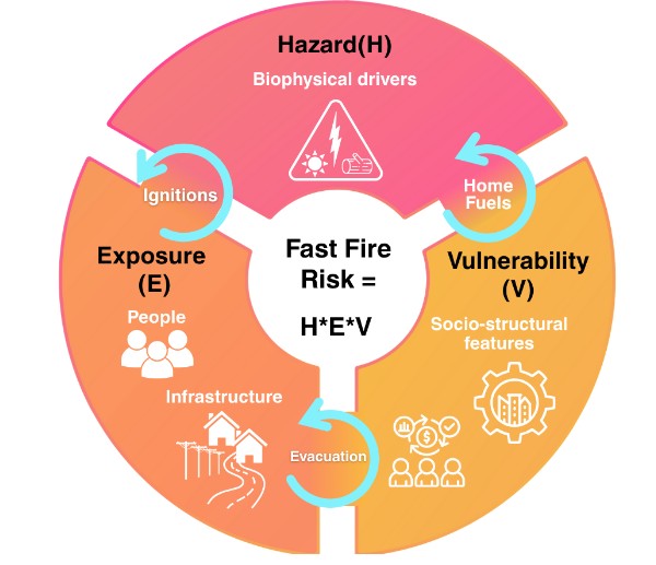
Figure 1. A convergent research approach to defining ‘fast fire risk’ that integrates across natural, social, and data sciences and engineering.
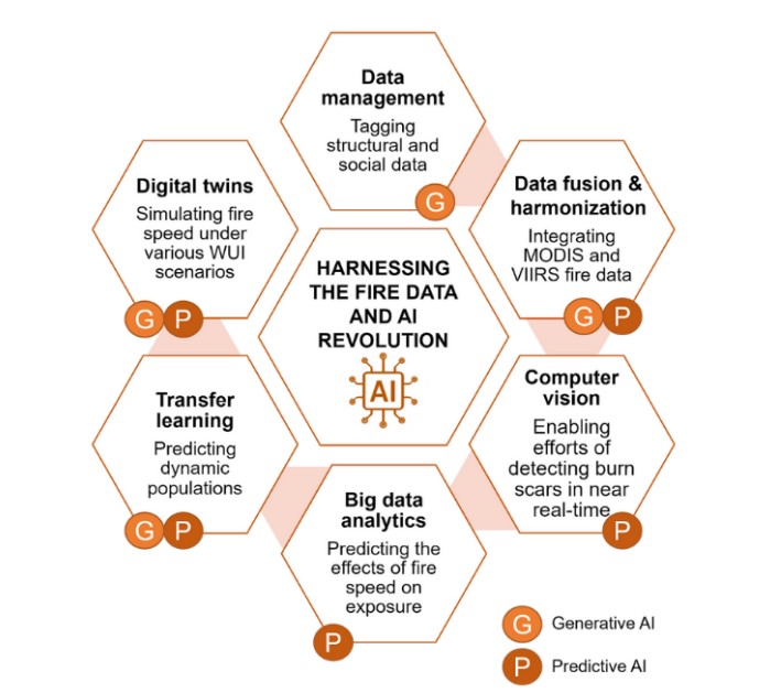
Figure 2. The constellation of Artificial intelligence applications for fast fire science. The team will work on applications ranging from data management and harmonization to big data analytics, transfer learning, and digital twinning.
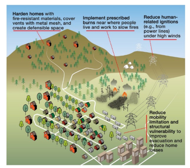
Figure 3. Fast fire risk-reduction solutions that slow fires down or prepare communities could include better building, prescribed burning, reduced human-related ignitions, and greater understanding of social-structural vulnerability across the built environment. Artwork by Kathy Bogan/CIRES.







Funders