Project Description
The number and extent of wildfires are increasing the western U.S. forests. These forests are important in regulating the amount of carbon in the atmosphere. Wildfires have reduced the amount of carbon western U.S. forests accumulate by 15-fold since the 1980s. In this research we explore the critical question: is carbon recovery in burned forests changing as regional warming and consequent wildfire disturbance size increase. Innovative remote sensing using Unmanned Aerial Systems (UAS), NEON's Airborne Observatory, and the GEDI satellite allow rapid monitoring of forest structure at very high resolution across thousands of hectares-providing a critical and often missing scale of observations. With these remote sensing data and other advances, regional to continental scale ecology can now explore large areas at very fine scales. However major impediments exist in taking full advantage of this new technology. Training to actually harness this data revolution significantly lags behind the data availability. This project addresses this need through training the next generation of Earth analysts in data and compute-intensive science, cutting-edge ecosystem carbon measuring techniques, and large-team collaboration.
This project will advance fundamental understanding of how above-ground biomass recovery trajectories vary as a function of fire size and severity, drought, and conifer forest type (1984-present) across the western U.S. This project will: 1) apply emerging UAS technologies and methods to estimate tree-level above-ground biomass to then explore carbon recovery post-fire in the NEON southern Rockies domain; 2) explore fundamental drivers of carbon recovery post-disturbance across a chronosequence of fire history in conifer forests of the western U.S. using space-based observations; and 3) build a national network of over 100 ecosystem scientists, predominantly graduate students, who will be enabled to conduct data-intensive exploration of forest carbon dynamics in response to disturbance within NEON domains. Education efforts include a distributed graduate seminar taught simultaneously at five universities, open education modules delivered on Earth Lab's learning portal for Earth data science that currently reaches tens of thousands of users, and a Forest Carbon Codefest that to build collaborative efforts around key methodological advances, data coding challenges, and cloud-compute workflows. Overall, this project will lead to better understanding of when forests shift from carbon sinks to carbon sources under changing fire regimes and help to train the next generation of data-capable Earth scientists.

Figure 1: Workflow for detecting seedlings regenerating after wildfire from UAS imagery. A) The orthomosaic derived from Structure from Motion (SfM) photogrammetry. B) The point cloud derived from the structure from motion is colored based on point elevation. C) The digital elevation model created by removing above-ground tree points. D) The canopy height model developed using the digital elevation model and the points above ground. E). Initial detection of tree top locations using the canopy height model. f) Delineation of individual vegetation crown area using treetops and the point density and canopy height models.
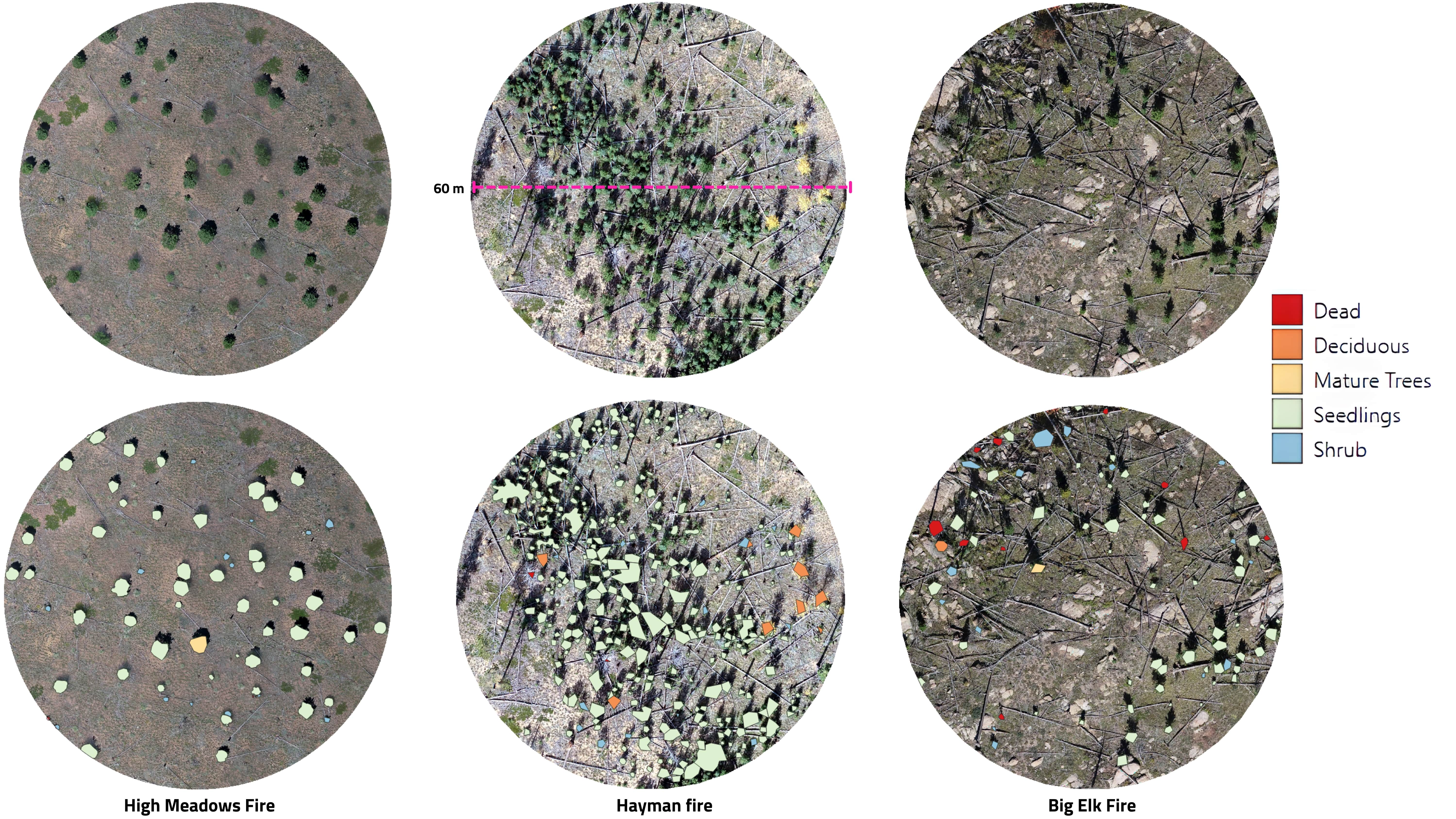
Figure 2: Seedling prediction across three example field plots (top row: raw imagery, bottom row: classified polygons). Different colors represent the standing vegetation types. Cyan: conifer mature trees, Green: deciduous, purple: shrubs, and Burgundy: Standing dead, Brown: conifer seedlings.
Funding for this project was provided by NSF Award #DEB 1846384 (NSF CAREER)
Featured Blogs





Funders