FIRED - Fire Event Dilineation
Daily fire perimeters globally
Fire activity is increasing across many areas of the globe. Understanding how social and ecological systems respond to fire is an important topic for the coming century. But many countries do not have accessible fire history data. There are several satellite-based products available as gridded data, but these can be difficult to access and use, and require significant computational resources and time to convert into a useful product. We developed a software package called FIRED (Fire Event Delineation) which automatically downloads and processes all of the source files for an area of interest from the MODIS burned area product, and runs a spatiotemporal flooding algorithm that converts those hundreds of grids into a single fire perimeter shapefile. When we first wrote the paper presenting the algorithm, we ran it for the coterminous United States (Balch et al 2020). At that time, it was obvious that the potential was there for a global product, but scaling from one country to global presented some big data problems that took some time to solve. In fall of 2021, we solved enough of the issues to finally run the FIRED algorithm on every country with substantial fire activity to create fire perimeter datasets for every country on the globe. We intend to update these datasets annually, as we continue to improve the efficiency and flexibility of the underlying algorithm. The data are available on CU Scholar, and there are also links to the on our github repository (below).
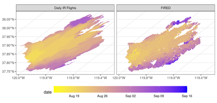
Here you can see the 2013 California Rim Fire progression from August into September as delineated by hand-drawn maps from thermal Infrared imagery as part of the nightly flights in the US National Infrared Operations (NIROPS) program (left) and the FIRED product (right)
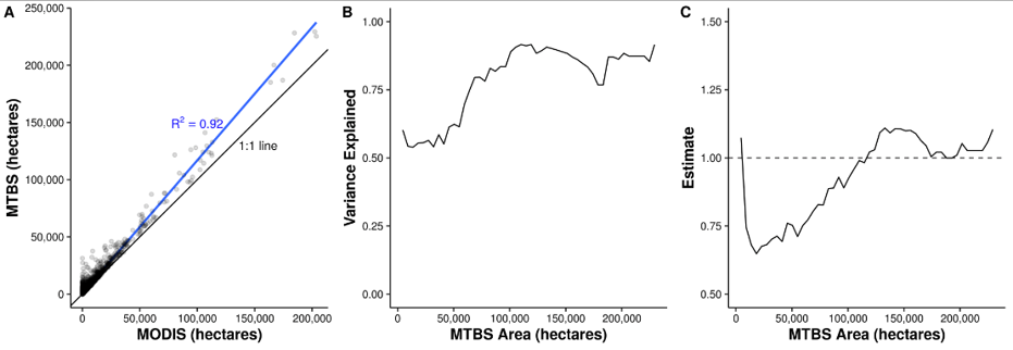
FIRED final perimeter algorithm accuracy was tested against the US Monitoring Trends in Burn Severity (MTBS) database. In A, the FIRED (MODIS) product generally predicts a little more area than MTBS, as we expected due to the fact that MTBS perimeters do not have holes in them when there are unburned patches. In B, we calculated the strength of the relationship between FIRED and MTBS for 5,000 acre size class bins, showing how the satellite-based FIRED has more uncertainty for small fires, and starts performing really well for very large fires (around 75,000 + acres):
Get More Information
- Github repo: Open Source Software
- Algorithm Theoretical Basis
- Data Access
- Global Dataset Descriptor